When is the absolute best time to visit Tamhini Ghat?
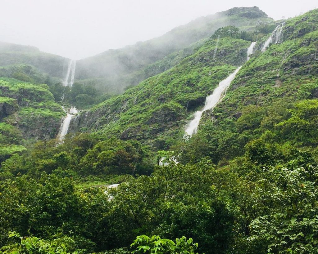
The monsoon season (July to September) is the prime time to experience Tamhini. The region receives some of the highest rainfall totals in Maharashtra, causing the entire landscape to transform into a vibrant green backdrop cloaked in dense fog, with hundreds of seasonal waterfalls dropping off the sheer basalt cliffs.
What is the Tamhini Wildlife Sanctuary?
Officially designated as a protected area, the Tamhini Wildlife Sanctuary serves as a crucial biodiversity corridor. It is home to leopards, barking deer, wild boars, and the Malabar Giant Squirrel (Shekru—the state animal of Maharashtra). It is also a global hotspot for unique amphibians and endemic monsoon flora.
Where is Tamhini Ghat located, and how do I reach it?
Tamhini Ghat lies along the road connecting Mulshi to Mangaon.
From Pune: It is highly accessible—roughly 60 km westward via Paud Road, making it an easy 1.5 to 2-hour drive.
From Mumbai: It is roughly 140 km away via the Mumbai-Pune Expressway (exiting toward Hinjawadi/Mulshi) or via the Goa Highway (NH 66) hitting Mangaon first.
Are the road conditions safe during heavy rains?
The road has been extensively widened and completely resurfaced, offering a much smoother driving experience than in previous years. However, because the area receives torrential downpours, low visibility due to sudden cloud cover and thick fog is highly common. Always drive with headlights or fog lamps turned on, and maintain a conservative speed around the blind mountain bends.
What is the famous "Plus Valley" Trek in Tamhini?
Plus Valley is an incredible, medium-difficulty trek named because the unique gorge is shaped precisely like a plus sign (+) when viewed from above. Unlike traditional mountain climbs, this trek is an inverse hike—you start on the ridge and descend deep into a rocky, boulder-filled valley canyon flanked by towering vertical rock walls.
What are the accommodation options in and around Tamhini?
Stays are largely concentrated around the Mulshi Lake area (on the Pune side) or the Kundalika River rafting belt (on the Konkan side). Options range from luxury lakeside glass villas and boutique wellness resorts to rustic lakeside camping tents and village farmstays.
Create a detailed 1-day road trip itinerary for Tamhini Ghat from Pune, highlighting major scenic stops, restaurants, and viewpoints?
This detailed 1-day road trip itinerary from Pune to Tamhini Ghat is optimized for a seamless driving loop, ensuring you beat the heavy weekend traffic and catch the mountain vistas at their misty best.
Route Overview & Drive Logistics
Total Driving Distance: ~140 km (Round trip from Pune).
Total Driving Time: 4 to 5 hours split across the day.
The Route: Pune City ➔ Chandani Chowk ➔ Pirangut ➔ Paud ➔ Mulshi Dam ➔ Tamhini Ghat ➔ Kundalika Valley Viewpoint (and return).
Best Departure Time: 06:00 AM. Leaving early is critical during weekends to bypass the massive bottlenecks that form near Chandani Chowk and Pirangut Ghat.
Step-by-Step 1-Day Road Trip Schedule
🚗 Morning: Lakeside Cruising & Rural Breakfast
06:00 AM – 07:30 AM: Escape the City to Mulshi Lake
Hit the road via Paud Road. As the urban sprawl fades, you will climb the small Pirangut Ghat and drop into the scenic Mulshi Lake catchment area.
07:30 AM – 08:30 AM: Breakfast Stop at Basho's Restaurant or Local Tapris
Pull over at Basho's Restaurant right along the Mulshi backwaters for a relaxed breakfast with a panoramic lake view. If you prefer a quick, rustic bite, stop at any of the local village tapris (stalls) near Paud for steaming hot Misal Pav, Kanda Poha, and ginger tea.
08:30 AM – 09:30 AM: Stop 1 – Mulshi Dam Viewpoint & Backwaters
Drive slow along the winding lakeside road. There are several stone-paved laybys where you can safely park to enjoy the vast expanse of the Tata hydro-reservoir shrouded in early morning low clouds.
🌫️ Mid-Day: Deep into the Misty Ghats & Canyons
09:45 AM – 11:15 AM: Stop 2 – The Kundalika Valley Viewpoint (The "Independence Point")
As you cross the threshold into Tamhini Ghat proper, make a sharp right turn toward the famous Kundalika Valley Viewpoint.
The View: This is a spectacular, sudden geographical drop where the Deccan Plateau ends and a sheer, 1,500-foot deep forested canyon plunges into the Konkan plains below. In peak monsoons, massive waterfalls line the opposite cliff walls, and fierce wind currents force mist to blow rapidly straight up the gorge.
11:30 AM – 01:00 PM: Stop 3 – Tamhini Main Waterfall & Secret Streams
Drive further down the main ghat road. You will pass the main Tamhini Waterfall, which features a large, safe pool at its base where water cascades over wide basalt steps. For a quieter experience, park at the smaller bridges further down where crystal-clear mountain streams cut across the rock beds before plunging over the edge.
🍽️ Afternoon: Authentic Regional Lunch
01:15 PM – 02:45 PM: Lunch Stop at Hotel Quick Bite or Garva Hotel
Head to Hotel Quick Bite or Hotel Garva located right along the Tamhini highway corridor. These rustic roadhouses specialize in authentic, fiery Maharashtrian Varadi/Gavran chicken thalis, Pithla Bhakri, and freshly sliced Sukhya Kolambi (prawns) cooked on wood-fired earthen stoves.
🌲 Evening: The Hidden Valley & Sunset Return
03:00 PM – 04:00 PM: Stop 4 – Plus Valley Overlook & Devkund Trailhead View
Before turning back toward Pune, drive down to the final ridge of the ghat to catch a glimpse of the striking Plus Valley gorge opening. Take a moment to stretch your legs amidst the rolling green meadows that mark the start of the Konkan lowlands.
04:15 PM: Turn your vehicle around and begin the steady ascent back up toward Pune.
05:30 PM – 06:15 PM: Stop 5 – Sunset tea at Café Horizon
Make a final casual stop at a hillside cafe like Café Horizon or a roadside stall overlooking the eastern side of the Mulshi hills. Watch the sunset turn the rain-slicked mountain roads into glowing gold ribbons.
08:00 PM: Arrive back in Pune city, beating the late-night return rush.
Pitstop & Restaurant Directory
Premium / Aesthetics: Basho’s Resort & Restaurant (Mulshi) — Great multi-cuisine menu, clean washrooms, and premium lakeside seating.
Authentic Local Vibe: Hotel Garva / Hotel Quick Bite (Tamhini Ghat) — Excellent for spicy regional thalis and rustic stone-ground masalas.
Quick Cafes: The Leaf Café or Café Horizon — Perfect for continental snacks, sandwiches, and a reliable cup of hot coffee or hot chocolate mid-drive.
Driver's Safety Checklist
Headlamp Health: Ensure your vehicle's fog lights and hazard indicators are functioning perfectly. Tamhini can get completely blanketed in a thick, soup-like white fog within seconds, dropping visibility down to under 5 meters.
No Parking Zones: Never park your car directly underneath loose, exposed mudbanks or overhanging rocky ledges along the ghat bends. Heavy downpours can cause swift, spontaneous mudslides or falling boulders.
Carry Offline Maps: Network connectivity (especially on Jio and Airtel networks) drops to zero once you cross the Mulshi reservoir line. Download the offline Google Map of the Pune-Mulshi-Tamhini route before leaving home.
Compare Tamhini Ghat and Amboli Ghat in a side-by-side table focusing on location, crowd density, and distinct features?
Both Tamhini Ghat and Amboli Ghat are stunning mountain passes piercing through the crest of the Western Ghats, but they cater to completely different travel vibes and geographic zones.
Here is how they stack up side-by-side:
FeatureTamhini GhatAmboli Ghat
Primary LocationNorth-Central Maharashtra (Mulshi to Mangaon corridor).Southernmost edge of Maharashtra (Sindhudurg district, bordering Goa/Karnataka).
Distance from Major Cities• Pune: ~60 km
• Mumbai: ~140 km• Goa (Panaji): ~90 km
• Belagavi: ~70 km
• Mumbai/Pune: ~490+ km
Crowd DensityVery High (Weekends): Extremely popular for quick, single-day road trips from Pune and Mumbai. Saturdays and Sundays see heavy bumper-to-bumper traffic and bustling roadside stalls.Low to Moderate: Mostly acts as a scenic transit route for travelers heading to Goa. It feels significantly more secluded, peaceful, and untouched by heavy weekend day-tripper crowds.
Terrain & AltitudeAverage elevation is around 2,200 feet. It features wide, rocky plateau lands that suddenly drop into massive, deep-cut canyons.Highest point reaches around 2,260 feet. The landscape features incredibly dense, humid tropical rainforests and sharp, hair-pin curves cutting through misty, vertical cliffs.
Key Scenic AttractionsMulshi Lake backwaters, the vertical drop of Kundalika Valley, and the inverse canyon trek of Plus Valley.The iconic multi-tiered Amboli Main Waterfall (equipped with stone stairs), Hiranyakeshi River Origin Temple, and Kavalshet Point.
Distinct Features & VibeThe Adventure & Drive Hub: Best known for dramatic canyon views, sweeping misty highway drives, and proximity to river rafting (Kundalika River).The Biodiversity Hotspot: Receives incredible rainfall (~7,500 mm annually), making it a world-famous eco-tourism hub for discovering rare amphibians, reptiles, and bioluminescent fungi.
The Verdict: If you want a quick, dramatic, high-energy monsoon drive close to Pune or Mumbai, pick Tamhini Ghat. If you are looking for a tranquil, deeply forested nature retreat or a scenic detour on your way to Goa, choose Amboli Ghat.