
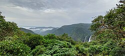
Chorla Ghat

Chorla Ghat

Chorla Ghat is a spectacular mountain pass nestled in the Sahyadri mountain range of the Western Ghats. Situated at an elevation of roughly 800 meters (2,600 feet), it sits right at the scenic tri-junction where the borders of Goa, Karnataka, and Maharashtra meet.
​While modern travelers know it for its misty valleys, dense subtropical rainforests, and seasonal waterfalls, its historical roots tell a much wilder story.

The History of Chorla Ghat

​1. The “Passage of Thieves”

​The very name Chorla stems directly from the Hindi/Marathi word Chor, which translates to “thief” or “bandit.” Historically, this region was dense, highly inaccessible, and heavily forested, making it the perfect geographical hideout.

​Following the British administration’s enactment of the Thuggee and Dacoity Suppression Acts between 1836 and 1848, colonial forces cracked down heavily on bandits across the Deccan Plateau. Desperate for refuge, many of these outlaw groups fled into the dense, misty jungles of this specific ghat. They would hide deep within the forest canopy and occasionally ambush traders traveling between the coastal ports of Goa and the inland kingdoms.

​2. A Strategic Trade and Military Route

​Long before it was a highway, Chorla Ghat was a vital, rugged transit route connecting the Konkan coast (including Portuguese-governed Goa) to major inland empires like Kolhapur and Bijapur on the Deccan Plateau.

​Because of its strategic elevation, controlling the pass meant controlling the flow of goods and troops. Hidden deep within the ghats lies Sada Fort, a 300-year-old outpost built by a Desai Sardar (a noble commander) serving in the army of Chhatrapati Shivaji Maharaj. Shivaji’s sons, Sambhaji and Rajaram, reportedly utilized this fort to keep a watchful vigil over enemy movements in the valleys below. The fort even briefly fell to Tipu Sultan during his expansive military campaigns.

FAQs

Where exactly is Chorla Ghat located, and how do I get there?
It is located on State Highway 4, about 50 to 55 kilometers northeast of Goa's capital, Panaji (Panjim), and roughly 55 kilometers from Belagavi (Belgaum) in Karnataka. The most popular way to reach it is by renting a car or bike, or hiring a local cab from North Goa or Belagavi.
When is the best time to visit?
The monsoon season (June to September) is arguably the most magical time to visit. The entire landscape turns a striking emerald green, fog rolls over the roads, and dozens of seasonal waterfalls (like the Twin Vajra Waterfalls) come alive. However, if you prefer clearer driving conditions and outdoor trekking without heavy rain, the post-monsoon months of October to March offer beautiful, pleasant weather.
Is it safe to drive through Chorla Ghat?
Yes, the roads are generally well-paved, but it is a classic mountain pass featuring sharp hairpin turns, steep inclines, and heavy mist. During the monsoons, the roads can get slick and visibility drops significantly. It is highly recommended to drive cautiously, avoid overtaking on blind curves, and try to complete your mountain drive before nightfall unless you are a seasoned hill driver.
What are the main attractions to see around the area?
Aside from the scenic drive itself, top highlights include: ​The Twin Vajra-Sakla Waterfalls: Spectacular cascading falls best viewed during the rains. ​Anjunem Dam: serene reservoir located at the foot of the ghats offering panoramic viewpoints. ​Mhadei Wildlife Sanctuary. massive biodiversity hotspot surrounding the ghats, home to rare birds, panthers, and bioluminescent fungi that glow in the dark during damp seasons. ​Sada Fort Trek. popular trek leading to the historical ruins of the Maratha outpost and nearby caves.
Provide a detailed trekking guide for the Sada Fort trail in Chorla Ghat, including difficulty level and route details?
The trek to Sada Fort and the adjacent Sada Waterfall (also called Sādagundi Falls) is one of the most rewarding off-the-beaten-path adventures in the Western Ghats. Located on the rugged border between Goa, Karnataka, and Maharashtra, this trek seamlessly blends historical ruins, dense jungle canopy, volcanic caves, and a massive 200-meter-tall waterfall. ​Trek Profile ​Difficulty Level: Moderate to Difficult (Highly weather-dependent) Distance: 8 to 12 km (Round trip from Sada Village) / Up to 18 km if starting further out during peak monsoon. ​Duration: 5 to 7 hours total (including exploration time at the fort and waterfall) Starting Point: Sada Village, Belagavi district (near the Chorla Ghat route) Best Time to Trek: July to October (Peak monsoon to early post-monsoon) Route Details & Trekking Phases ​Phase 1: The High-Altitude Plateau & Sada Fort Ruins ​The trek kicks off at the remote, rustic Sada Village. The first leg of the route crosses a flat, exposed volcanic rock plateau. The Fort Exploration: Right at the edge of the village, you will encounter the remaining ramparts, step-wells, and boundary walls of the 300-year-old Sada Fort. The fort sits perched perfectly on a steep cliffside. Looking north and west, you will get spectacular, uninterrupted views of the deep, forested valleys of Maharashtra and Goa below. Underground Caves: If you take a steep detour upwards from the plateau (at about 2,900 feet above sea level), you can explore a series of unique underground caves formed by prehistoric volcanic activity. Phase 2: The Forest Canopy (The Jungle Plunge) ​As you move past the fort and edge closer toward the waterfall, the open plateau suddenly drops away, and you plunge directly into a dense, semi-evergreen forest. The Terrain: The tree canopy here is incredibly thick, shutting out direct sunlight and dropping the temperature. The trail becomes a maze of massive buttress-root trees, giant hanging creepers, and moss-covered volcanic boulders. Monsoon Challenge: During the rains, this section becomes a prime habitat for jungle leeches. Wearing proper gear is essential here. Phase 3: The Steep Descent & Stream Crossings ​To reach the deep pool at the base of the waterfall, the trail shifts into a technical, challenging descent. The Footing: You will navigate steep slopes with slick, muddy soil and wet, loose rocks where you’ll frequently need to use your hands for balance. Water Crossings: Depending on the exact trail variation, you will need to cross fast-flowing mountain streams. During peak monsoon, these streams can reach knee-deep heights with a deceptively strong current. Phase 4: The Final Amphitheater & Sada Waterfall ​Emerging from the thick jungle canopy, the roar of the water acts as your guide. You walk out into a colossal rocky amphitheater. ​The Sada Waterfall dramatically plunges 200 meters (over 650 feet) down a sheer, stark cliff face right between two massive hills. The mist from the waterfall cools down the entire valley, making it a perfect spot to rest before facing the exhausting uphill climb back to the village. Essential Trekking Tips ​Hire a Local Guide: The trails inside the dense forest are completely unmarked, and it is incredibly easy to lose your bearings or wander down a dangerous cliff edge. Local guides from Sada village know the safest stream-crossing points and paths. ​Leech Protection: If you are trekking between July and September, carry salt, turmeric, or anti-leech socks. The forest floor crawls with them during the wet months. Footwear: Avoid casual sneakers. You absolutely need sturdy trekking shoes with deep lug patterns to grip slippery wet boulders and mud. Self-Sufficiency: Sada is a pristine, low-footfall area. There are zero shops, stalls, or facilities past the village. You must carry all your own water (at least 2–3 liters) and energy snacks. No Camping: Camping is strictly prohibited and unsafe inside the surrounding forests due to the presence of wildlife like sloth bears, leopards, and bisons. Plan to start early in the morning so you can

Price From : ₹4500/-

Address

Near Avaloormadam temple, thathampally po, pin code 688013, Alleppey, Kerala, India