
Neriamangalam

Neriamangalam

Situated along the banks of the Periyar River on the border of the Ernakulam and Idukki districts, Neriamangalam is universally celebrated as the “Gateway to the High Ranges.” If you are driving up to Munnar from Cochin or the plains of Ernakulam via National Highway 85, this is the exact geographic threshold where the flat terrain transforms into winding mountain roads, and the air noticeably begins to cool.

Historical Context

​Neriamangalam’s modern history is a story of human resilience, royal engineering, and a vital lifeline built out of a massive natural disaster.

  • The Catastrophe of the ’99 Floods’ (1924): In July 1924 (the year 1099 in the Malayalam calendar), Kerala was hit by a historic deluge known as the “Great Flood of 99.” The torrential rain completely wiped out the existing British-built railway, ropeway, and mountainous trade routes that connected the tea estates of Munnar and the spice-rich high ranges to the coastal ports of Kochi. The entire high-range economy ground to a halt.
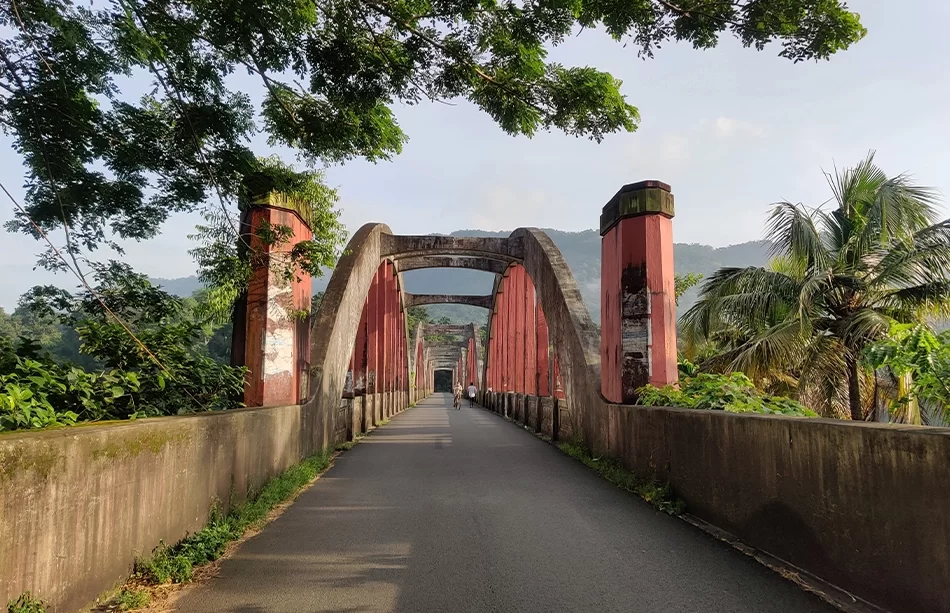
  • The Birth of Asia’s First Class-A Arch Bridge: To restore trade and connectivity, the Regent Maharani of Travancore, Sethu Lakshmi Bayi, ordered the construction of a new all-weather road from Aluva to Munnar and a grand bridge spanning the Periyar River at Neriamangalam. Construction began in 1924. To commemorate the launch, the Queen installed a monumental stone monument known as the Ranikallu (The Queen’s Stone), which still stands near the site today.
  • The Royal Inauguration (1935): Designed by British engineer Arthur Thomas Gill, the iconic Neriamangalam Bridge was officially opened to the public on March 2, 1935, by the last Maharaja of Travancore, Sree Chithira Thirunal Balarama Varma. It was a legendary engineering feat—celebrated as the first Class-A concrete-and-granite arch bridge in Asia.
  • The Secret Traditional Recipe: To ensure it could withstand the fierce, unpredictable currents of the Periyar River during monsoon seasons, engineers built the bridge’s five arches using traditional Surkhi mortar—a meticulous compound of lime, granite, burnt clay, and a sticky organic binder made from jaggery (molasses). This ancient compound gave the bridge unparalleled elasticity and strength. It has effortlessly survived the devastating state-wide floods of both 1961 and 2018 without requiring any major structural repairs.

FAQs

Why is Neriamangalam called the "Cherrapunjee of Kerala"?
​Neriamangalam records some of the highest average annual rainfalls in the entire state of Kerala. Because it catches the absolute brunt of both the Southwest and Northeast monsoons against the foothills of the Western Ghats, it remains intensely humid, perpetually lush, and intensely green throughout the year—earning it its famous rainy nickname.
Can you see the historical Ranikallu (Queen's Stone)?
​Yes. The Ranikallu is located right by the side of the National Highway near the Neriamangalam bridge approach. It stands as a protected historical marker that travelers frequently stop to photograph. It marks the precise spot where the royal family kicked off the foundational infrastructure that opened up Idukki’s mountains to the rest of the world.
What major tourist attractions are near Neriamangalam?
​Because it marks the base of the mountains, Neriamangalam is surrounded by beautiful natural pitstops: ​Cheeyappara and Valara Waterfalls: Located just a short drive further up the highway toward Adimali, these cascading waterfalls are iconic roadside stops for travelers heading to Munnar. Inchathotty Suspension Bridge: Situated nearby, this is one of the longest suspension bridges in Kerala, stretching across the Periyar River and offering breathtaking views. The Salim Ali Bird Sanctuary (Thattekad): Located just a short distance downstream, this is a world-famous dense forest reserve packed with rare endemic and migratory birds.
What is the primary economy of Neriamangalam today?
​While it historically grew as a trade transit point for Munnar’s tea and cardamoms, Neriamangalam's local economy is driven heavily by agriculture. The rolling foothills are covered in expansive rubber plantations, along with cash crops like black pepper, cocoa, nutmeg, and coconut. It is also home to the Neriamangalam Hydroelectric Project, a key power station commissioned in 1961.
Is there a good time to stop at Neriamangalam during a Munnar trip?
​It is a fantastic spot to take a brief 15-to-20-minute break on your drive up to Munnar. Mornings are particularly magical when the mist hangs low over the Periyar River. There are several local tea stalls and small eateries on either side of the historic bridge where you can grab a hot cup of tea and enjoy the cool river breeze before tackling the steep mountain hairpin turns ahead.

Price From : ₹400/-

Address

Near Avaloormadam temple, thathampally po, pin code 688013, Alleppey, Kerala, India