
Chaturangapara

Chaturangapara

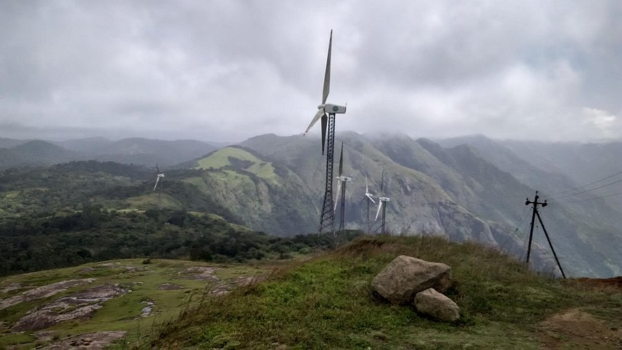
Chaturangapara (often spelled Chathurangapara) is a breathtaking border destination situated in the Udumbanchola taluk of Idukki district, Kerala. Positioned on the edge of the Western Ghats ridge, it overlooks the vast plains of neighboring Tamil Nadu and is famous for its high-velocity winds and majestic windmill landscape.

Historical Context & Background

​1. The Square Fort Strategy (Etymology)

​The name Chaturangapara translates directly to “Square Rock” or “Chess Rock” in Malayalam and Tamil (Chaturangam meaning chess or a square formation, and Para meaning rock).

​Historically, this ridge line served as an invaluable strategic watchpoint for the rulers of the region. The natural rock formations at the peak resembled a square fortification or a defensive grid line. From this vantage point, guards could spot incoming armies or traders coming up through the mountain passes from the plains of Tamil Nadu long before they reached the high-altitude settlements.

​2. The Ancient Trade Route Link

​Before modern highways were engineered, Chaturangapara sat adjacent to ancient pedestrian and pack-animal trade routes. Spices like wild cardamom, pepper, and forest produce grown on the Kerala hills were carried down through these rugged gaps to the prominent trading markets of Bodinayakanur and Theni. In return, essential grains, textiles, and salt were brought up the mountains.

​3. Transition to Renewable Energy

​For most of the 20th century, Chaturangapara remained an isolated, wind-battered agricultural border outpost. However, in the late 1990s and early 2000s, energy experts identified the location as one of the most powerful natural wind corridors in South India. The high-velocity gusts funneling through the mountain gap led to the establishment of the massive Chaturangapara Wind Farm. The installation of these towering wind turbines completely transformed the visual and economic landscape of the ridge, turning a remote border point into a modern eco-tourism landmark.

FAQs

General & Travel Queries ​, Where exactly is Chaturangapara located and how far is it from Munnar?
Chaturangapara is situated right on the Kerala-Tamil Nadu border, approximately 45 kilometers from Munnar town and about 12 kilometers from Santhanpara. It can be reached via a beautiful drive through the Munnar-Kumily highway, followed by a short diversion toward the border ridge.
Why is Chaturangapara famous among travelers?
It is renowned for three main features: its incredibly strong, continuous winds that can literally make it difficult to stand upright, its stunning 360-degree panoramic views (where you can see the low-lying farmlands of Tamil Nadu on one side and the green hills of Kerala on the other), and the rows of massive active windmills lining the crests.
Is it necessary to hire a 4x4 Jeep to reach the viewpoint?
While regular cars and two-wheelers can travel up to a certain point near the base, the final stretch leading directly up to the main viewpoint ridge consists of rough, steep, and unpaved terrain. Hiring a local 4x4 Jeep Safari from Santhanpara or Nedumkandam is highly recommended for a safe and hassle-free ride to the peak
Experience & Safety , What is the best time of day to visit Chaturangapara?
The absolute best times to visit are early morning (before 6:30 AM) for a spectacular sunrise over the Tamil Nadu plains, or late afternoon (4:00 PM to 6:30 PM) for sunset. Watching the sun rise through the spinning blades of the windmills as the mist clears from the valleys below is a magical experience.
Are there any specific safety precautions visitors should take?
Yes. Because the ridge line drops off sharply into the plains thousands of feet below, visitors must exercise extreme caution near the cliff edges, especially given the unpredictable and violent wind gusts. Additionally, there are no safety railings or barriers in many spots. Visiting during heavy monsoon rains or thick fog is not advised due to slippery rocks and zero visibility.
Can we see the windmills up close, and do they operate all year?
Yes, the access road runs right alongside the massive turbine structures, allowing you to stand directly beneath them and hear the thunderous whoosh of the blades. They operate year-round, but their power generation peaks during the high-wind months of June to September

Price From : ₹400/-

Address

Near Avaloormadam temple, thathampally po, pin code 688013, Alleppey, Kerala, India