
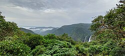
Chorla Ghat
Chorla Ghat is a spectacular mountain pass nestled in the Sahyadri mountain range of the Western Ghats. Situated at an elevation of roughly 800 meters (2,600 feet), it sits right at the scenic tri-junction where the borders of Goa, Karnataka, and Maharashtra meet.
While modern travelers know it for its misty valleys, dense subtropical rainforests, and seasonal waterfalls, its historical roots tell a much wilder story.
The History of Chorla Ghat
1. The “Passage of Thieves”
The very name Chorla stems directly from the Hindi/Marathi word Chor, which translates to “thief” or “bandit.” Historically, this region was dense, highly inaccessible, and heavily forested, making it the perfect geographical hideout.
Following the British administration’s enactment of the Thuggee and Dacoity Suppression Acts between 1836 and 1848, colonial forces cracked down heavily on bandits across the Deccan Plateau. Desperate for refuge, many of these outlaw groups fled into the dense, misty jungles of this specific ghat. They would hide deep within the forest canopy and occasionally ambush traders traveling between the coastal ports of Goa and the inland kingdoms.
2. A Strategic Trade and Military Route
Long before it was a highway, Chorla Ghat was a vital, rugged transit route connecting the Konkan coast (including Portuguese-governed Goa) to major inland empires like Kolhapur and Bijapur on the Deccan Plateau.
Because of its strategic elevation, controlling the pass meant controlling the flow of goods and troops. Hidden deep within the ghats lies Sada Fort, a 300-year-old outpost built by a Desai Sardar (a noble commander) serving in the army of Chhatrapati Shivaji Maharaj. Shivaji’s sons, Sambhaji and Rajaram, reportedly utilized this fort to keep a watchful vigil over enemy movements in the valleys below. The fort even briefly fell to Tipu Sultan during his expansive military campaigns.