
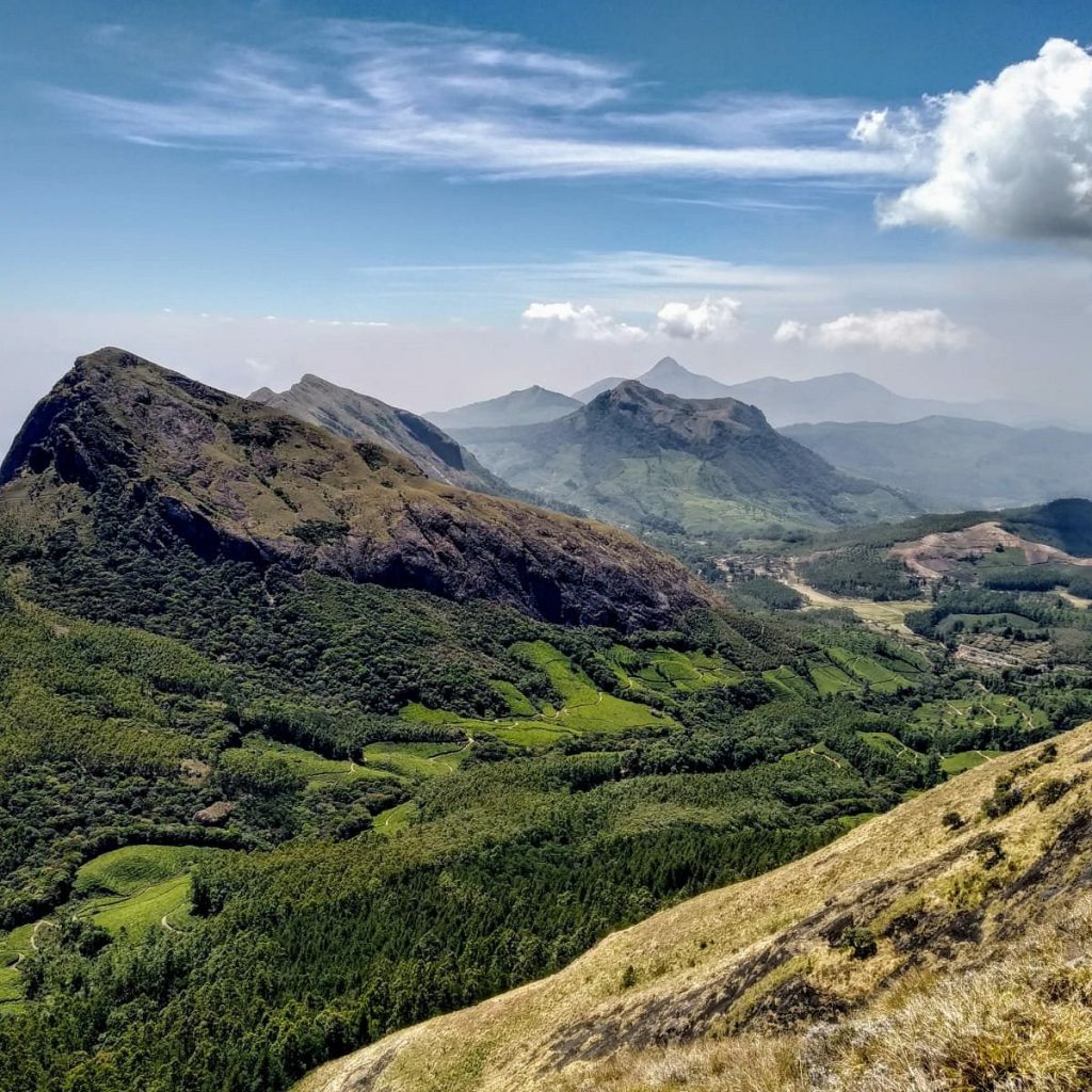
Meesapulimala

Meesapulimala

Rising to a soaring 2,640 meters (8,661 feet) above sea level, Meesapulimala is the second-highest peak in the Western Ghats and South India, surpassed only by Anamudi. Located roughly 25 kilometers from Munnar along the interstate border between Kerala (Idukki district) and Tamil Nadu (Theni district), it has transformed from a hidden geographic boundary into one of India’s most iconic eco-trekking destinations.

Historical & Cultural Context

​The story of Meesapulimala is deeply intertwined with its striking geography, ancient geology, and colonial-era transformations.

  • The “Tiger with a Moustache”: The name itself is highly descriptive in Malayalam and Tamil. It breaks down into Meesa (moustache), Puli (tiger/leopard), and Mala (hill/mountain). When viewed from certain low-lying southwestern angles or from the adjacent valleys, the mountain’s interconnected ridge of eight peaks dramatically resembles the face of a snarling wild cat with long, sweeping whiskers formed by the high-altitude grassy spurs.
  • Ancient Precambrian Foundations: Geologically, Meesapulimala belongs to the ancient Southern Granulite Terrain. The rock formations here—primarily charnockites—are roughly 2.5 billion years old, shaped under extreme temperature and pressure deep within the earth long before being elevated by tectonic shifts millions of years ago.
  • The Boundary Stone & Colonial Surveyors: For centuries, this rugged ridge served as a natural barrier between the ancient kingdoms of the Tamil plains and the hill tribes of Kerala. During the British colonial era, the peak became a critical point of calculation for the Great Trigonometrical Survey of India. Colonial planters and surveyors used the high ridges of Meesapulimala to map out land concessions, eventually leading to the establishment of the nearby Kolukkumalai Tea Estate (the highest organic tea plantation in the world) just below the mountain’s eastern slopes.
  • The Shola-Grassland Ecosystem: Historically and ecologically, Meesapulimala is celebrated for its pristine “Shola” ecosystem—a unique prehistoric landscape consisting of dense patches of stunted tropical montane forests nestled inside valleys, surrounded by vast, rolling grasslands. This delicate environment is the native home of the endangered Nilgiri tahr and the vibrant red Rhododendron trees.

FAQs

How difficult is the Meesapulimala trek?
​The trek is generally rated as moderate to strenuous. The standard route from Rhodo Valley involves an 8-kilometer walk (one way) crossing eight separate hills. The terrain features steep uphill climbs over exposed grassy ridges, loose gravel, and high-altitude winds. It requires a decent level of physical fitness and is not recommended for young children or individuals with severe knee or respiratory issues.
Can I trek Meesapulimala without permission or a guide?
​No. Meesapulimala is located within a highly protected, ecologically sensitive forest reserve. Casual or unguided trekking is strictly forbidden. All treks must be booked and authorized through the Kerala Forest Development Corporation (KFDC). The KFDC provides mandatory local expert guides to accompany trekkers, ensuring safety and protecting the local wildlife habitat.
What are the stay options available at the base camp?
​To control tourism footprint, the KFDC operates exclusive high-altitude wilderness lodgings near the starting point of the trail. The popular options include: ​Base Camp Tents: Tented accommodations situated at an elevation of roughly 6,000 feet, complete with basic amenities and evening campfires. Rhodo Mansion: A sturdy, stone-built dormitory/lodge located higher up in Rhodo Valley at 7,500 feet. Sky Cottage: A secluded, premium glass-walled cottage built on a cliffedge—highly sought after for its panoramic isolation.
When is the best time to visit?
​The ideal trekking window is from October to March. During these winter months, the weather is crisp, the mornings feature stunning "sea of clouds" formations below the peak, and visibility across the Tamil Nadu plains is at its clearest. Note on Monsoons: The monsoon months (June to September) bring heavy downpours, thick fog that drops visibility to zero, and a high population of leeches. The trails become dangerously slippery and are often suspended during extreme weather.
What wildlife might I encounter during the trek?
​The high-altitude grasslands and shola corridors are bustling wildlife havens. Trekkers frequently spot the endangered Nilgiri tahr grazing on the steep cliffs. Other resident species include Indian gaurs (wild bison), sambar deer, barking deer, wild elephants, and rare birds. Though elusive, the region is also home to the Nilgiri marten, wild dholes (dogs), sloth bears, and leopards.
Do the Neelakurinji flowers bloom here?
​Yes. The slopes of Meesapulimala are among the primary habitats for the famous Neelakurinji (Strobilanthes kunthiana) shrubs. These flowers carpet the hillsides in a breathtaking sea of violet-blue once every 12 years. The last synchronized mass bloom occurred in 2018, making the next spectacular event anticipated around 2030.

Price From : ₹400/-

Address

Near Avaloormadam temple, thathampally po, pin code 688013, Alleppey, Kerala, India